Fri,Jul 4,2014
 Global ambassadors of ecotourism gather in Nanjing
 Taiwan woman marries into Kazak family, 100 sheep plus a flat as dowry
 College girls take graduation photos under water in Chongqing
 Cartoon: Xi and football
 Chinese influence sweeps ROK
 Post-90s beauty boxer grapples four men
 3,000-year-old tea town through lenses
 22 archaeological sites along Silk Road in China
 Football babies, Samba dancers embrace 'World Cup'
 Beautiful scenery along China’s Grand Canal
A local publishing house in China has published a vertical map of the country giving equal weight to land and sea areas. The new map is different because, unlike traditional horizontal maps that show the islands in the South China Sea in cut-away boxes in a bottom corner, it gives a good idea of China's land and sea territories at a single glance, and thus strengthens its territorial claims.
The map, however, has evoked strong reactions from Vietnam and the Philippines. The two countries have criticized China's "unreasonably expansive claim" and urged it to respect international laws. Besides, Philip Goldberg, the US ambassador to the Philippines, has said China's "artificial creations" have no basis in international law.
Contrary to the accusations, the publication of the map can help promote Chinese public's territorial awareness and high-light its historic title over the South China Sea and is thus a legitimate move.
This is not the first time these countries have questioned China's historic title over the South China Sea or wrongly accused Beijing of violating the United Nations Convention on the Law of the Sea. China is a party to the UNCLOS and has been adhering to its principles. Moreover, there is no conflict in China abiding by the UNCLOS and substantiating its sovereign claim over the islands and the adjacent waters by high-lighting its historic title. After all, reference to historic titles is part of the UNCLOS.
Historic title generally signifies the rights a state has had over certain waters for a considerable time, which can be sovereign rights or other non-exclusive rights unrelated to territorial sovereignty such as traditional fishing rights. From the perspective of the UNCLOS, historic title is considered an exception to the applicability of the provisions on sea boundary delimitations.
For instance, according to Article 10 of the UNCLOS, related provisions on bays do not apply to the so-called historic bays, and Article 15 says provisions on the delimitation of the territorial sea between states with opposite or adjacent coasts do not apply "where it is necessary by reason of historic title or other special circumstances". Article 47 stipulates that, "if a part of the archipelagic waters of an archipelagic state lies between two parts of an immediately adjacent neighboring state, existing rights and all other legitimate interests which the latter state has traditionally exercised in such waters" shall continue and be respected.
China has a long history of exploring and exploiting the South China Sea and, hence, has historic title over the sea, which is proven by the nine-dash U-shaped line marked on official maps since the 1940s. Although China's Exclusive Economic Zone and Continental Shelf Act says conflicting claims on the exclusive economic zone and the continental shelf by China and countries with opposite or adjacent coasts shall be settled on the basis of international law, it clarifies that "the provisions of this act shall not affect the historical rights of the People's Republic of China".
 |
 Featured hutongs in Beijing
 Separate college entrance exam
 Flash mob dance
 Picturesque scenery of Ghost City
 Children attend First Writing Ceremony
 Female master poses for graduation photos with son
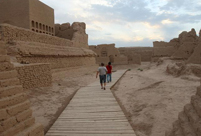 Silk Road, China's Grand Canal listed as World Heritage Sites
 PKU students imitate famous paintings in real-person photos
 Chinese 'Slumdog Millionaire'
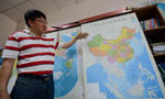 Islands in S. China Sea better shown on new vertical atlas of China
 Girl takes father’s portrait to travel the world
 Images of Xi'an: Part one
 In Pictures: Female fans of World Cup
 Top 20 hottest women in the world in 2014
  China's top 10 representative architectures
Day|Week|Month